Umenoki-toge「梅野木峠」 MTB circuit (22.5km, 480m climb, 1hr40) from Ome
See Umenoki MTB-01 for GPS (Garmin Edge 705) data and map for a similar route which includes an extra very steep climb.
Category: Road: 18.1km (4.3km on closed road, another 1.2km on very quiet road), Dirt road: 4.4km
Route: Ome, Sawai, Umenoki-toge, Horse stable, Umegaya-toge, Ome (Opposite direction to map and profile!)
Map:
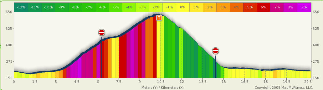
Profile:
Notes:
This is easier if done anti-clockwise, doing most of the climbing on a paved
road. The dirt road is not so steep but has some loose stones in some areas.
There's a good view of Kanyonosato on one corner.
The descent from Umenoli-toge to Sawai on the paved road is dangerous when the
surface is wet, so it's better to climb this way and descend on the dirt road
instead.
See [link TBA] for an alternative loop which uses the main road to Kanyonosato
instead of the dirt road requiring an extra climb of about 170m to the Horse
stables.
See http://cchp.dion.jp/googlemaps/20060311_gm_route.htm for a report including sections of this route - there is a photo of the required turn off from Yoshino-kaido.